
‘Very strong’ El Niño predicted in 2026. What does it mean for WA weather?
El Niño is back, and this year, it’s likely to be stronger than normal, according to forecasters.
As of July 9, there was an 81% chance of a “very strong” El Niño from October through December, according to the National Oceanic and Atmospheric Administration’s Climate Prediction Center.
That’s an 18% increase in likelihood in just one month.
Forecasters previously predicted a 63% chance of a “very strong” El Niño and a 25% chance of a “strong” El Niño for the season running from November to January.
If the temperature anomaly follows previous patterns, that “would rank among the largest El Niño events in the historical record going back to 1950,” the prediction center said in a July 9 update.
What does this mean for Washington state? Here’s what we know:
What is El Niño?
Weather can be incredibly unpredictable, so scientists do their best to track elements that may lead to severe weather.
“El Niño and La Niña are two opposing climate patterns that break these normal (weather) conditions,” NOAA said on its website. “Scientists call these phenomena the El Niño-Southern Oscillation cycle.”
During El Niño, trade winds weaken and warm water is pushed toward the west coast of North and South America.
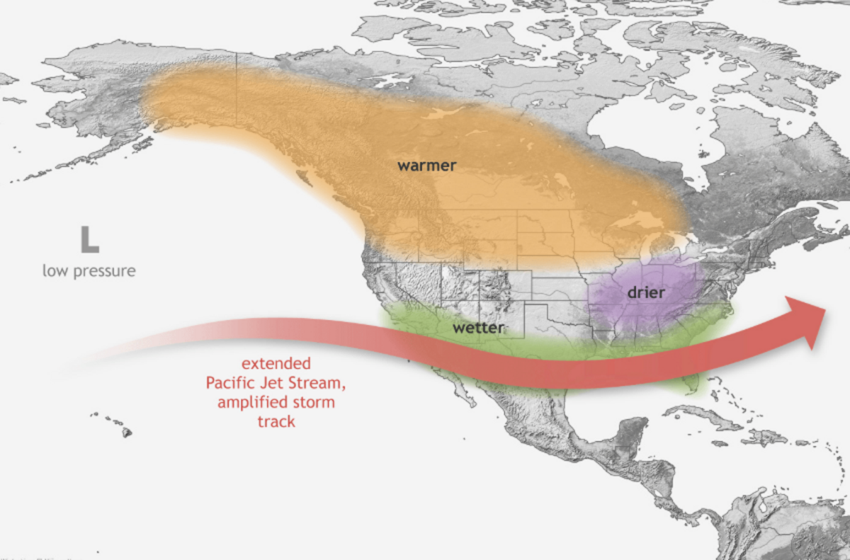
As a result, weather in the northern United States and Canada is “drier and warmer than usual,” NOAA said, while the Gulf Coast and Southeast see wetter-than-normal weather with increased flooding.
During El Niño, sea surface temperatures particularly rise near the equator, according to the U.S. Department of Agriculture’s Northwest Climate Hub.
This phase of the cycle usually occurs every two to seven years, and can last between a few months and a full year.
This year, NOAA forecasts a 97% chance El Niño will last through early spring 2027.
According to the Washington State Department of Ecology, El Niño is considered “very strong” when ocean surface temperatures rise by at least 2 degrees Celsius above normal.
When this occurs, the effects tend to be “a little more extreme,” state officials said.
La Niña is the cool phase of the cycle.
“La Niña has the opposite effect of El Niño” as trade winds push more warm water toward Asia, NOAA explained, leading to “drought in the southern U.S. and heavy rains and flooding in the Pacific Northwest and Canada.”
What causes El Niño?
The tropical trade winds that blow across the Pacific Ocean typically move warm waters east towards Asia, according to NOAA.
When surface level temperatures in the ocean are warmer than normal, however, the winds can weaken and possibly change direction.
This brings hotter temperatures to the western parts of the Americas, triggering El Niño effects.
What impacts will El Niño have on Washington state?
El Niño normally has the most impacts during winter, according to the Northwest Climate Hub.
According to NOAA, the Pacific Northwest is expected to experience warmer winter conditions following El Niño.
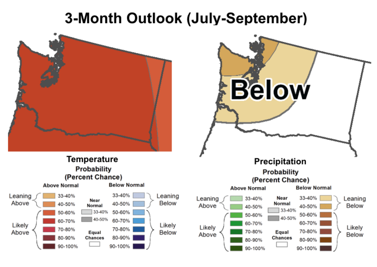
NOAA’s summer outlook indicates “elevated chances of warmer-than-normal conditions statewide and drier-than-normal conditions across western Washington,” the University of Washington’s Washington State Climate Office said.
Parts of the country will see wetter conditions than normal, but that will be further south, around California and Texas.
The Northwest Climate Hub said that El Niño can contribute to drought, wildfire, marine heatwaves and shoreline erosion in the region.
The Pacific Northwest likely won’t just experience less precipitation overall, but also more precipitation falling as rain instead of snow, the climate hub said.
Past El Niño events have affected salmon populations and other marine life in Washington state, hurting local fisheries. In 2023, El Niño led to a record-setting marine heat wave.
Will El Niño worsen the drought in Washington?
In April, the Washington State Department of Ecology issued a drought declaration for all watersheds in the state due to low snowpack and multiple years of precipitation deficits.
It’s the fourth year in a row that at least part of the Evergreen State has been in a drought emergency, the Washington State Department of Health said.
“It’s not over, and with the arrival of El Niño conditions, it likely won’t be over any time soon,” Washington State Department of Ecology communications manager Jimmy Norris said in a June 26 update.
The Washington State Climate Office’s July 2026 Climate Outlook expressed concerns for increased drought conditions across the state.
While El Niño can generally increase the odds of having a below-normal snowpack in Washington state, this is not always the case, according to the climate outlook.
“Intrinsic year-to-year variability continues to be a larger factor in our winter conditions than ENSO alone,” Jacob Genuise wrote in the climate outlook. “Nevertheless, (El Niño-Southern Oscillation) is the best predictor we have of winter conditions, and currently it hints toward a possibly drier and warmer winter pattern.”
The current three-month outlook indicates a 60% to 70% chance of above-normal temperatures in July through September.
Certain parts of Washington state will experience below-normal precipitation levels during the same time period, particularly the Puget Sound and central and northern Olympic Peninsula.
“This doesn’t necessarily spell doom for our hopes of a snowy winter,” Norris said. “While it is true El Niño generally means warmer winter and poor snowpack, there is still uncertainty about what El Niño will mean for our winter next year.”
Norris noted that the last three very strong El Niño events experienced in Washington state all resulted in normal to above-normal snowpacks, despite the other effects they had on the weather.
This story was originally published July 14, 2026 at 5:00 AM with the headline "‘Very strong’ El Niño predicted in 2026. What does it mean for WA weather?."